
Decision Support Systems for farm management [Professional]
Introduction
Decision support systems, data analysis and data mining have become significant tools for improving business in professional world. The emerging technologies are making the precision agriculture omnipresent and allow potential for enriching it with computer-assisted decision support systems for farm management.[1]

Decision Support Systems play an important role in modernize and optimizing production answering the needs for increased productivity and decreased environmental impact. Farm management in terms of inputs and outputs, weather monitoring and efficient decision making in everyday agricultural procedures are significant actors for a successful agricultural production.
1. Climate and Environment
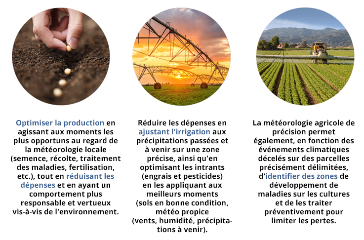
The climate affects agricultural activities in all their dimensions. All the meteorological factors (solar radiation, temperature, precipitation, wind, evaporation) are taken into account for the construction of living matter. Weather and climate have an influence on the plant, but it is the soil that is the laboratory in which these energies are used. The latter is constantly changing in a sense that depends essentially on atmospheric conditions. Understanding these climatic conditions is essential to optimize production and reduce expenses thanks to precision agricultural weather. [2]
Related Smart Farming Technology Product
- Weather Measures
Weather Measures is expert in precision weather services and proposes technical assistance on all aspects of a meteorological project. By integrating multi-source data and technology including X-band radar, Weather Measures provides detailed information on extended areas with high spatial and temporal resolution (a ground resolution of 150 to 300 meters), very useful for precision agriculture. [3]
Related Projects
- N-TOOLBOX
The N-TOOLBOX project was aimed at addressing the root causes of agricultural sources of water contamination and improving uptake of strategies to reduce losses of nitrogen (N) from agricultural sources to water. The overall aim of N-TOOLBOX was to develop a ‘toolbox’ of cost effective technologies to be implemented at the farm level to protect water from nitrate pollution.
The project general aim is:
1. producing a catalogue of innovative and cost effective technologies to be implemented in hotspots for N losses in the European Union
2. developing an improved NDICEA decision support tool for N management at the farm level
3. testing the N-TOOLBOX catalogue and decision support tool at the farm level
4. monitoring water quality, N use efficiency and costs and benefits on case study farms
5. documenting the implementation of the N-TOOLBOX approach at the farm level.
An extensive review of academic and non-peer reviewed literature was conducted during the reporting period. The N-TOOLBOX decision tree was developed and could be used by farmers and policy makers to identify strategies most appropriate for their specific system.
Some key findings included the following:
1. feeding strategies could improve the efficiency of N use on livestock farms. On dairy farms milk urea testing could be used as a tool to indicate if N supply in feed was optimal.
2. manure management solutions should include ‘thinking outside the box’ approaches, e.g. anaerobic digestion which reduced manure volume, allowed for more targeted spreading of the digestate and reduced greenhouse gas (GHG) by producing energy.
3. farmers in northern regions could reduce N losses from grazed areas if simple monitoring tools were available that indicated the onset of net drainage.
4. similarly,N leaching could be reduced substantially by optimising N application rates to cropland using a combination of soil testing, in-field crop growth assessments and the use of dynamic simulation models.
5. catch crops offered the potential to trap N mineralised late in the year after the main crop was harvested.
6. strategies for irrigated cropland needed to include approaches that not only optimised fertilizer N application rates, but also the use of irrigation water.
The N-TOOLBOX project laid the groundwork for the development of grassroots’ approaches to solving the problem of nitrate pollution from agriculture. In the following reporting periods the project would document successes and failures and use these experiences to produce a blueprint for use of the N-TOOLBOX approach at the farm and catchment level. [4]

N-TOOLBOX is a collaborative project involving experts in N management at the farm level from four leading European institutions.
The Nafferton Ecological Farming Group (NEFG), Newcastle University, is a research group within the School of Agriculture focusing on low-input and organic approaches to crop and livestock management. NEFG soil researcher Dr. Julia Cooper coordinates the N-TOOLBOX project, with assistance from soil scientists Dr. Elizabeth Stockdale and Dr. Robert Shiel. Agronomy advice is provided by Dr. Steve Wilcockson.
The Louis Bolk Institute (www.louisbolk.nl) (LBI, Driebergen, Netherlands) is a private scientific research institute focussing on agriculture, food quality and health founded in 1976. In the area of agriculture, the LBI started with a focus on organic agriculture and livestock systems, but recently has redirected its research towards the wider area of sustainable agriculture.N-TOOLBOX activities at LBI are lead by Ir. G.J.H.M. van der Burgt who is a specialist in the NDICEA model and has worked on many institute projects on the theme of nutrient use efficiency, predominantly nitrogen. Assistance will be provided by Dr. Ir. C. J. Koopmans, a senior researcher and coordinator of the Soil and Plant department at LBI and Dr. Ir. B. Timmermans.
The Universidad Politécnica de Madrid (www.upm.es) is the oldest and largest Spanish technical university. N-TOOLBOX at UPM is a project of the Agsystems Research Group (http://www.etsia.upm.es/GRUPOSINV/AgSystems) which is lead by Miguel Quemada. Professor Quemada´s research focuses primarily on nitrogen budgets in agricultural systems and the effects of agricultural practices on nitrate leaching. Antonio Vallejo also provides expertise on nitrogen budgets in agricultural systems and the effects of agricultural practices on nitrate leaching and nitrous oxide emissions. Economic analyses are provided by Alberto Garrido, an Associate Professor and expert on the economics of natural resources and risk assessment. Additional assistance with environmental datasets, including climate and soil data analysis, will be provided by Dr. Chiquinquira Hontoria,an Associate Professor and Soil Scientist.
The University of Aarhus (www.au.dk) Vegetables and Crop Physiology Group (VCPG), is responsible for N-TOOLBOX activities in Denmark. This research group is part of the Department of Horticulture, within the Faculty of Agricultural Science at UA (www.agrsci.org). Dr Hanne L. Kristensen leads the project in Denmark, with additional support from Dr Jørn Nygaard Sørensen. Work at Aarhus in the past has focussed on:
- effects of catch crops and green manures in farming
- developing models for plant-soil interactions in the rhizosphere
- model based decision support systems to optimise N use in crop rotations.[5]
2. Farm management
Related Smart Farming Technology Products
- Vintel
The itk’s mission is to help farmers optimize the yield and quality of their crops, and reduce risks on their farm, while preserving the environment through better management of inputs (irrigation, fertilizer, phytosanitary products). With 1 million ha of crops covered worldwide, and more than 300,000 cows connected, itk is one of the world’s leading agri-intelligence companies.
Vintel, is a decision support tool for all vineyard managers, all vines and all production objectives.
With Vintel:
- Observe block water status
- Anticipate your vineyard operations
- Manage water stress: irrigation, enherbement, according to your production objective
- Optimize: Water, time, money
- Decide: Future vintage roadmap
- Simulate: New planting projects
- Weather data management
Optimal irrigation in fruit and nut trees is essential to maximize yield and optimize fruit quality. To apply the optimal irrigation, growers needs to consider multiple factors related with the crop, soil, irrigation system, production objective as well as weather forecast. Irrigation management is therefore extremely complex and time consuming for growers because they need to take decisions in a weekly basis for multiple blocks with distinct characteristics. Grower decisions on irrigation management can be facilitated if grower adopt the ‘Orchard’ mobile application developed by itk. Vintel Orchards® is a user-friendly application where the grower can easily introduce their block characteristics, compare their irrigations to the optimal irrigation and receive alerts when blocks are not well managed.
The main objectives of this project are to develop user-friendly mobile applications for scheduling irrigation in multiple crops based on crop water demand and forecasted weather, to facilitate the application of regulated deficit irrigation practices in orchards, and provide weekly irrigation recommendations and alerts from potential deviation from optimal irrigation.
In this App, you can:
- Introduce your almond variety and year of plantation
- Introduce your soil properties and irrigation system information
- Introduce the phenology of your trees including full bloom, leafing, hull split, harvest and leaf fall
- Define and visualize your irrigation strategy during the season
- Select when you want to start your irrigation scheduling and your irrigation calendar[6]

Find out more about Vintel:
- Orchid
Orchid is an innovative solution designed to accompany market gardening growers in optimizing their production above ground.
Orchid provides expertise to collect and synthesize all data that improves productivity and product quality while respecting the environment.
Agriculture has undergone several changes over time, the next will be technological with precision farming, it is agriculture 4.0.
At the same time, infrastructure and greenhouse cultivation techniques have been progressively progressed. This method of cultivation, which is mainly used for market garden products, provides an answer to the consequences of climate change, which is why the number of greenhouse farms is increasing, particularly in Europe.
Precision farming takes all forms of farming that are already highly automated, which has been optimized to reduce input consumption and improve the quality of the crop products.
We use a network of sensors of our design whose architecture allows to adapt to any culture and any surface of exploitation. The collected elements are graphically reproduced, allowing the professional to monitor their culture and then these data are valued by algorithms to assist the producer in the management of his inputs. In addition we develop in partnership with a research laboratory a tool for measuring the quality of culture products that allows a real-time diagnosis and whose data will enrich the mathematical models.
- Manage your production efficiently
- Control your water resources and inputs.
- Improve quality and performance.
- Help preserve the environment[6]
- Weenat
Weenat allows the farmers to optimize their resources, by bringing them localized information in the plot to support their decisions. Weenat help farmers to:
- Prevent health and climate risks
- Assist in water resource management
- Make adjustments from sowing to harvesting
Weenat offers a new agronomic approach by providing farmers with adapted, affordable, and most of all easy-to-use solutions. With our innovations, we help them manage their resources by optimizing their time, supporting them in their decision-making and consequently make their everyday lives easier.
Weenat’s Solutions:
Connected weather
Follow the weather of your plot in real time to adjust your interventions
Crop protection
Optimize your plant protection strategy from your smartphone
Irrigation
Drive your irrigation reliably and accurately
Frost
Measure the temperature as close as possible to the buds[7]

Find out more about Weenat:
- VitalFields
VitalFields is a digital agriculture company that offers an easy-to-use farm management system for farmers to plan, manage and analyze their field activities, including simplified tracking and reporting of all crop inputs to help ensure compliance with European Union environmental standards.
Founded in 2011 and available in seven European countries, VitalFields offers an easy-to-use tool for farmers to plan, manage and analyze their field activities, including simplified tracking and reporting of all crop inputs to help ensure compliance with European Union environmental standards.
VitalFields has raised a total of $2.2M in funding over 4 rounds. Their latest funding was raised on May 27, 2015 from a Series A round.
Is funded by 9 investors. Tera Ventures and Eesti Arengufond are the most recent investors.
Uses 17 technology products and services including Google Analytics, G Suite (formerly Google Apps for Work), and Apache Web Server.
Is actively using 27 technologies for its website. These include Viewport Meta, IPhone / Mobile Compatible, and SPF.
Is ranked 7,372,583 among websites globally based on its 1,811 monthly web visitors.
VitalFields has $190.4K in estimated revenue annually. VitalFields competes with FarmLogs, Granular and OnFarm. [8]

View the following video, to understand more:
- SMAG
The agricultural world is constantly innovating to develop new technologies for a precision farming that is more cost-effective for farms, more efficient for production, and more environmentally friendly (lower energy consumption and inputs).
SMAG’s solutions, which are part of a precision farming approach, are interoperable with remote sensing via drone or satellite. Ultimately, the processing of the data collected in agreo and atland makes them indispensable Decision Support Tools to manage fertilisation and thereby optimise yields.
Remote sensing makes it possible to optimise fertilisation and yields at each new crop year by mapping plots, monitoring crop growth status, establishing an agronomic diagnosis, and so on. The results of this complementary service, provided by our expert remote observation partners, may now be imported and analysed in Agreo and Atland.

Also, the plot management software applications Atland and Agreo communicate with the embedded consoles of many agricultural machinists (John Deere, Müller Elekctronik, Massey Ferguson, CCI, Fendt, Kverneland, Vicon, Tecnoma, Topcon, Valtra, etc.).
Farmstar is a satellite assisted Decision Support Tool service offered by Arvalis – Plant Institutes in partnership with Airbus Defence and Space. Farmstar enables wheat, barley and rapeseed crops to be observed from satellite images taken throughout the crop year. Retrieving data in Agreo and Atland in the form of maps thus allows farmers to adjust nitrogen inputs on their plots, in the right place, and at the right time.
Developed by Geosys, the Cerelia tool combines satellite remote sensing, agronomic expertise and knowledge of the field to analyse the status of winter cereal or rapeseed crops during the crop year and hence detect growth anomalies. Interoperable with our plot management software, this service allows the farmer to access modulation or nitrogen input maps directly in Agreo or Atland, enabling the implementation of fertilisation adjusted to the variability of each plot.
To optimise farmers yields and crop quality, Airinov offers a nitrogenous fertilisation recommendation service via drone flight on the wheat and winter barley plots. A turnkey offer compatible with Agreo and Atland, this remote sensing service allows farmers to order a plot mapping from their distributor (cooperative, wholesaler) to establish the actual fertiliser needs of the plots (recovery of the plot data before the drone flight., retrieval of modulation maps in Agreo / Atland)
As part of a precision agriculture approach, Wanaka offers remote sensing services on soft wheat or rapeseed crops. From Agreo or Atland, the farmer orders customised advice on the dose of fertiliser to apply. Wanaka takes aerial photographs via drone or ULM, then analyses and interprets the collected data according to the environmental parameters of the farm entered beforehand into the plot management software (soil, type of seeds, climate, etc.). Finally, modulation maps are returned to the agricultural operator who can thereby carry out the spreading.[9]
- N-eXpert
Fertilization is one of the most important field operation in arable farming. Fertilization is a cost relevant activity for growing crops and is an environmental risk. To minimize environmental risks and cost and to optimize yield, profitability and fertilizer use, sites-specific management is a new paradigm and farming concept that simultaneously enables optimal farm profitability and environmental sustainability. The chances of site-specific management practice are widely accepted by the farmer community and the technical preconditions are available on the market. But to be practically able to adapt precision fertilization farmers need to know the actual nutrient status of the cropland and to have a system available that is easy to be integrated into their work flows and is flexible for their ad-hoc and spontaneous decisions making due to changing weather and workforce handicaps.
The system has to be reliable and cost efficient, allowing to document good farm practice. Today farmers still apply nutrients equally over entire fields but mostly consider the potential yield differences between the fields. Future optimization needs to consider the spatial pattern of the differences in nutrient status and nutrient demand within each individual field. When this is enabled then the variable rate technology (VRT) can be efficiently used to site-specifically adapt fertilizers to the actual demand of the crops for optimal yield formation and for minimized losses of nutrients.
With our Nutrient management and fertilization Expert service (N-eXpert) we support our customers with a dedicated decision making procedure regarding recent fertilization regulations. Our service enables farmers to achive higher nutrient efficiency at lower yield risks, and to simultaneously reduce the environmental pollution with nutrients in groundwater, waterbodies, and atmosphere (N2O emissions).[10]
Related Smart Farming Services
- GAIA EPICHEIREIN
The GAIA EPICHEIREIN services, which are being developed by NEUROPUBLIC since March 2013 utilizing the Internet and Cloud Computing, constitute one of the most innovative products demonstrated by Greece in recent years.
The services provided cover the following categories of agricultural entrepreneurship:
GAIA MANAGEMENT
Management and Financial Follow-Up Services/Tools
GAIA SUBSIDY
Subsidy and Public Regulatory Obligations Services
GAIA INFARM
Agricultural Production and Intelligent Agriculture Services
GAIA COMMERCE
Agricultural Products Trade and Promotion Services
GAIA SOCIETY
Online Agricultural Society
By using the GAIA EPICHEIREIN services, the private sector of agriculture and especially farmers or generally those employed in the agricultural field, obtain the comparative advantage that makes them stand out.
By using the services, Greek producers profit and benefit from:
- spending less time on bureaucratic and counterproductive issues
- the streamlining of bureaucratic procedures
- improving their relations with the Association they belong
- the transparency and the prices they are charged for
- the technical knowledge for the improvement of their production[11]
Learn more about GAIA:
- HIDROMOD
HIDROMOD provides services based on operational systems which are able to produce information according to the users’ needs. This information may derive from data (including real-time data), high resolution models or the combination of both.[12]
The systems operated by HIDROMOD include different interconnected numeric models, linked to real-time measurement systems, supporting decision-making by navigation and port authorities, water companies, hydroelectric production and public service organisations.
Some of the services made available by HIDROMOD are:
- High-resolution meteo-oceanographic forecast system for ports in Portugal, Brazil, Spain, Argentina and Colombia;
- Water quality forecast system for beaches in Barcelona and Biarritz (client: SUEZ ENVIRONMENT);
- Hydrocarbon spill forecast system for the Malacca and Singapore straits (client: IMO);
- Real-time management of measured and modelled data, to produce indicators and control discharges in the receiving environment of the Lisbon sewage system (client: EPAL);
- Real-time management of measured data and numeric forecasts supporting the Galicia Accidental Sea
- Contamination Territorial Plan (CAMGAL Plan) (client: INTECMAR);
- Leakage forecast system for a water distribution network in Oman (client: L&T).
The following image, shows the allocation of warm sea water

Ever since its foundation, HIDROMOD has always promoted a strong connection to the Research and Development (R&D) universe. Along with the technical skills of our co-workers, this connection has allowed our company to maintain a high technological level to this day, mostly through the use of internally developed tools (models, graphic packages, databases and GIS). HIDROMOD is also a Silver Application Development Partner of MICROSOFT CORPORATION.
This active involvement in R&D has potentiated an effective link to the scientific community, by participating in international research projects such as EROCIPS, FIGARO, MYWATER, INSEA and ECOMANAGE. We have also co-oriented bachelor, masters and doctorate theses, as well as the publication of scientific articles.
In tandem with this knowledge integration effort, HIDROMOD has developed and maintained two tools which are fundamental for the services we provide: the MOHID Modelling Service (www.mohid.com) and the AQUASAFE Platform (www.aquasafeonline.net).
MOHID
MOHID is a modelling system with several modules, for hydrodynamic calculation (including the possibility of using different options for horizontal and vertical meshes), water quality (including formulations similar to the WASP, CE-QUAL and ERSEM models), dispersion phenomena (including Lagrangian and Eulerian approximations), sediment transport (including suspended sediment transport and sand transport formulations) and wave propagation (Boussinesq model).
AQUASAFE
The AQUASAFE platform aims to improve the efficiency of operation management, potentiating the use of real-time data and its integration with forecast and diagnostic tools. According to all the implemented concepts of the AQUASAFE platform, this integration is achieved by managing measured data (sensors, remote detection) and modelled data (meteorology, waves, currents, water or sewage distribution networks, run-off, river flow) in a uniform manner.

Related Projects
- Organic-AgriWare
“Organic-AgriWare – an application for the organic agriculture community” (2015-2016) is a project co-funded by the SmartAgriFoodand ICT-AGRI projects, and funded by the European Commission’s ERA-NET scheme under the 7th Framework Programme for Research.
As the organic agriculture market is rapidly growing worldwide and the demand for organic products is increasing, farmers and advisors need an easy way to acquire information for short-term and long-term planning in order to make the right decisions and plan ahead.
The problem that the project Organic-AgriWare wants to solve is the difficulty for organic agriculture stakeholders to access knowledge which is often dispersed at different online and offline locations.
The project aims to provide advisors and farmers with context-based access to organic community knowledge and it will help advisors to provide farmers with more accurate and concrete guidelines.
The implementation of Organic Agriware by Agro-Know is based on a strategic partnership with ICROFS and SEGES.
An application, which can be used on mobile phones, will be developed. Unlike other similar applications, Organic-AgriWare focuses on organic agriculture and will provide a unique access point to Organic Eprints and its open access scientific knowledge base.
All recent publications on organic information, dissemination material and organic sector specific data will provide every user with a broad range of state of the art research information on issues that are critical to the everyday reality of the organic agriculture community.
The Organic-AgriWare application could be used by anyone interested in organic agriculture, but is especially targeted customer segments like agricultural advisors and organic farmers.
Organic AgriWare is projected to be offered in a freemium model, which is a free version offering the ability to receive information on organic agriculture and users will be provided with advanced search tools in order to access relevant content from research papers hosted in Organic Eprints.
In a premium version, the users will be provided with tailor made scientific information based on their specific location, the specific crop type, local climate and current weather conditions.[13]
- AgriCloud
AgriCloud, a cloud-based precision farming (PF) management system for more efficient, sustainable production of crops in Europe.
The objectives are:
- final technical development,
- product demonstration through field trials with six pilot customers,
- market launch in five selected EU countries and
- market replication leading to a turnover of 28 m € within 5 years after launch.
Today, most farmers manage their crop by gut feeling, leading to inappropriate fertilization, plant damage and unnecessary environmental impact. AgriCloud is the first holistic FP approach, processing all available data from agronomic sensors, machinery and service companies and, backed by plant nutrition expert knowledge, facilitates a targeted use of fertilisers and herbicides, efficient machinery utilisation and workflow management. Farmers are operating a mixed stock of stand-alone agricultural machinery. AgriCloud meets their need for integrated solutions with only one data infrastructure for a coordinated, easy-to-use machinery control from one user interface.

By using AgriCloud, they will increase yield production between 3-10%, reduce lodging to 50-100%, reduce fertilisers by 12-20% and improve harvest efficiency by 12-20%. Their annual savings amount to approx. 130€/ha, which enables amortization of the AgriCloud invest within 1-1.5 years. The EU agricultural industry faces the challenge of responding to an increasing demand for food whilst at the same time having to ensure the sustainable use of resources. The Commission already identified PF as a key technology to solve this problem. However, European farmers have not yet adopted PF due to draw backs of existing solutions.
AgriCloud is able to solve those bottlenecks and contributes to Europe’s drive towards more competitiveness and long-term sustainability in agriculture as well as towards the recent EU Common Agriculture Policy (CAP).[14]
Start date: 1 May 2016
End date: 31 August 2018
Funded under: H2020-EU.2.3.1. H2020-EU.3.2.
Overall budget: € 1 359 000
EU contribution: € 951 300
Coordinated by: AGRI CON GMBH PRECISION FARMING COMPANY
Germany
Find out more:
- AGR_REPO
Application of environment friendly and efficient cultivation technologies, constant analysis of the agri- environment, rapid detection and prediction of unfavourable factors (pathologic and pest-related, internal water, etc. are essential for high quality cultivation monitoring of cultivation is realized based on a complex analysis that consists of field and remote sensed data and measurements. The most important project objective is the establishment – based on agricultural producers – of a geoinformatic technical advisory and information system supporting environmental friendly and efficient agro-technological interventions. The developed system is suitable for the detailed, plot-scale analysis of production site circumstances and yield, as well as the spatial-temporal evaluation of production technology parameters, it provides efficient support for prediction and at the same time a modern agricultural monitoring system will be created. Based on the mapping of pedological, land use and climatic conditions their organisation into an integrated geoinformation monitoring system allows us to determine the land use structure most complying to the ecological conditions of the given sites.
Specific objectives:
- elaboration and practical adaptation of environment friendly, integrated agronomically and ecologically efficient complex model-technologies;
- creation of an irrigation and plant protection geo-monitoring system, integration of different data sources
- development of a precision cultivation technology based on high resolution field and remote-sensed data;
- determination and adaptation of the possibilities of water storaging within the soil, elaboration of water preserving cultivation technologies, tillage processes
- design and elaboration of a high resolution soil monitoring system for the tracking of effects of land use in order to achieve a sustainable environmental condition
- elaboration of soil degradation protocols for the monitoring of soil degradation processes
- planning of agricultural land use in relation with climate change;
- as a result of the new possibilities the Institute will become an equal partner instead of “potential” partner within the relevant research field of ERA
- knowledge transfer with the surrounding countries (know-how, best practice)
- preparation of joint research projects with the project partners as a result of the closer relationship to be developed during and by means of the project activities
- creation of a research-based technical advisory system (and TAC)
- close professional relationship with SMEs, agricultural companies, integrators, producers (technical advice, decision support, by means of providing background data).
Grant agreement ID: 264123
Status: Closed project
Start date: 1 January 2011
End date: 31 December 2013
Funded under: FP7-REGPOT
Overall budget: € 1 362 249,20
EU contribution: € 1 199 551,37
Coordinated by: DEBRECENI EGYETEM [15]
- MODEM_IVM
The aim of the MODEM_IVM project was to develop an interactive, web-based decision support system (DSS) for integrated management of the vineyard. DSSs are computerised information systems that support decision-making activities.[16]
The project involved 8 partners (3 small and medium-sized enterprises (SMEs) and 5 research and technological development (RTD) institute performers) settled in 4 European Union (EU) countries (France, Italy, Portugal, and Spain). The partners integrated their different expertise for developing the complete DSS in terms of methodology, software and device. A prototype version of the DSS was delivered at the end of the project.
- eVineyard
eVineyard is like your electronic diary of vineyard management work, with a ton of other functionalities. Simply enter your activities in eVineyard once through a web or mobile application, you get multiple insights and outputs that can save you plenty of time and money.
Cost control
eVineyard helps you be in control of your costs, and rise profitability of your vineyard management operations. By entering your activities and purchases in eVineyard, you are building your own cost profile of your vineyard management operations without any additional work. With the help of costing module of eVineyard, you can keep track of your production costs, find bottlenecks and space for optimizations, and rise profitability of your vineyard.
Vineyard work traceability documents
With eVineyard, you can make sure that you stay compliant with all of the local and national regulations and laws, as well as to have a properly filled out records required by your certification agency. Simply enter the activities on your smartphone while you are performing them.
In eVineyard, you can print the work activities in the format you require – be it a national or international one, we very likely have you covered. If you want to make sure, just ask us in the chat.
No more losing records, and no more headaches with the vineyard work book. Every record you make will help you become a better winegrower in the future, and at the same time fuilfill the paperwork.
GIS and Mapping
If you are managing multiple vineyards, blocks and plots, then mapping module can help you to revise and plan your work visually over the parcels.
What is even more, for bigger wineries, in combination with GPS tracking of tractors, you may use mapping module to extract information about the activities which were done on the field.
Perfect for organization improvement in large wineries, as well as crucial for precision vineyard management practices, mapping functionality is one of the functionalities that require no additional work for vineyard managers and workers, but offer a great deal of valuable information.
Work organization
Estimate work times, organize your tractorists and workers, and manage your field work in a distributed way. This functionality is perfect for a bit larger vineyard management companies with multiple people managing the vineyard and is indeed scalable enough to encompass management of your seasonal workers as well. Our customers used work organization features on as much as more than 160 seasonal workers in the vineyard across a number of smartphones and tablets.
In eVineyard, you can print the vineyard workbook and data about stock of substances in the format you require – be it a national or international one, we very likely have you covered. If you want to make sure, just ask us in the chat.
No more losing records, and no more headaches with the traceability documentation. Every record you make will help you become a better winegrower in the future, and at the same time fuilfill the paperwork.
eVineyard won SAP HCP Challenge for CEE region in 2016 as the most innovative start-up using SAP HANA platform on the challenge. Partnering with, and using the latest high technology from, the world’s largest business software company SAP, allows us to say with confidence that eVineyard will always be able to provide you with the latest cutting-edge solutions for your challenges. [17]
Find out more:
- EOFARM
EOFARM project will cover the topic of Precision Farming (PF), one of the main applications of Earth Observation in the agriculture industry; it makes use of satellite images to help farmers in monitoring and managing crops from planting to harvesting. One of the main needs of farmers, in particular smaller ones which account for 80% of the UAA in EU27, is the possibility to increase yields while reducing the costs and environmental impacts of current crop production processes.
The developed system itself features several software modules that orchestrate the different image processing algorithms responsible for the production of consistent value-added maps like canopy greenness and leaf area index. Through distributed multitemporal analysis, the entire crop growth cycle can be continuously monitored through the analysis of time-series observations. These observations cover multiple crop growth cycles, offering invaluable information by linking weather statistical data with the start, the end and the duration of each growth cycle enabling critical decisions by direct comparison with the current crop growth state.[18]

EOFARM main objective is to launch in the market an innovative PF service which targets small farms (average size between 5-30ha), addressing a clear user need, and to enter in the emerging market of commercial applications of EO downstream services in agriculture, estimated to be worth approximately € 43 million in 2015.
EOFARM will be based on:
- an innovative algorithm able to integrate the algorithm indexes derived from NDVI(Normalized Difference Vegetation Index), LAI (LEAF AREA INDEX) and OSAVI (Optimized Soil-Adjusted Vegetation Index) for the production of 3 different kind of maps at the same time: crop vigor maps, vegetation status maps, green leaf maps,
- free satellite data derived from the constellation Copernicus (sentinel 2) and Landsat 8
- Open Geo, an open source solution
Find out more about EOFARM:
https://www.youtube.com/watch?v=rL9Zo-Mu0Qs

The impact on the EU Market of agriculture will be huge, considering that the current market for commercial applications of EO downstream services in agriculture is about € 34 million and the estimated EO downstream services Total Addressable Market (TAM) for the Agriculture sector amounts to approximately € 0,4 billion.
In this context The EOFARM project is expected to boost IPTSAT growth in terms of turnover, EBIDTA and employment opportunity.
Additionally EOFARM will have positive impacts on the small farmers by increasing productivity and sustainability by means of improved resource efficiency: it will possible to use less water, energy, fertilisers (especially phosphorus and nitrogen) and pesticides.[19]
- LIFE AGROintegra
The overall objective of LIFE AGROintegra is to minimize environmental risks in crop protection of cereals, vegetables, fruit trees and vineyard, through the demonstration of the feasibility of more sustainable alternatives for pests, diseases and weeds control, and the support to the implementation of Directive 2009/128/EC of the European Parliament and of the Council, establishing a framework for Community action to achieve the sustainable use of pesticides by the targeted stakeholders.

In order to achieve this goal, LIFE AGROintegra has set the following specific objectives:
- Demonstrate the environmental benefits of implementing alternative methods of crop protection.
- Contribute to zero residue in food, thanks to integrated pest management (IPM) techniques.
- Bring innovative IPM techniques closer to farmers via practical demonstrations.
- Develop a specific DST for farmers, proposing methods for pests, diseases and weeds control in each specific plot and situation.
- Raise awareness among farmers and advisors on the advantages of more sustainable crop protection methods, so that the transfer of knowledge, solutions and tools is comprehensive, effective and fast.
- Unify all knowledge generated in a working protocol that facilitates users the change towards an integrated crop protection.
Find out more about AgroIntegra:
In the LIFE AGROintegra project the following actions will be carried out:
- Creation of an Action Group to support the project involving the key players in the implementation of the IPM model in Navarre (farmers, cooperatives and agro-industries).
- Transformation of farms to the new IPM model, with new and innovative technologies that will be validated both technically and economically. It will be done at three levels:
- Field trials with new IPM techniques.
- IPM demonstrations in specific crops at agricultural plots, with the collaboration of farmers.
- Transformation of agricultural farms to the new IPM system.
- IPM tools:
Improvement and extension of the pests monitoring and warning system of INTIA-Government of Navarra, creating a new collaborative one with all users. - Development of IPM culture guides.
- Development of an online Advisory System based on a DST (HAD AGROintegra) that integrates all the knowledge acquired. This tool will be technically and economically validated in the farms of collaborating farmers.
- Promotion of the IPM model in Navarra through the awareness raising of key actors and advice and continuous training to farmers and technical advisors.
LIFE AGROintegra brings to the agri-food sector the most innovative IPM techniques through practical demonstrations that allow farmers to see first hand their technical and economic feasibility.

The Directive 2009/128/EC establishes the framework to achieve the sustainable use of pesticides, giving priority whenever possible, to alternative non-chemical measures. Thus, Integrated Pest Management (IPM), is defined as “the careful consideration of all available plant protection methods and subsequent integration of appropriate measures that discourage the development of populations of harmful organisms and keep the use of phytosanitary products and other ways of intervention to levels that are economically and ecologically justified and reduce or minimise the risks to human health and the environment”.
The IPM emphasises the growth of a healthy crop with the least possible disruption to agro-ecosystems and encourages natural mechanisms of pest control. The IPM tools can be displayed in a pyramid, which is divided into four different parts: – Preventive measures: They are placed at the base of the pyramid so they have priority over the other levels. These indirect control measures include agronomic practices such as choice of resistant varieties, cultural measures (crop rotation, time of sowing, fertilization management, irrigation, tillage…) and different practices to boost auxiliary fauna. – The next level is for risk evaluation, which it is a key in IPM strategy.
The Pest Monitoring and Warning System is an elemental tool to monitor pests and diseases and to establish strategies to control them. – Finally, if the previous work has been insufficient and, after applying preventive measures, the pest or disease is detected, there are curative measures available (direct control). Among these measures, the chemical control with pesticides is the last alternative than must be used to control pests and diseases.[20]
- CROPS
CROPS was a large-scale integrating FP7 EU research project in the theme Nanotechnologies, Materials and new Production Technologies within the call: Automation and robotics for sustainable crop and forestry management. The project was coordinated by Wageningen University & Research, Netherlands.The project started in October 2010 and was accomplished in September 2014. The SWEEPER research project followed-up the CROPS project.
CROPS has developed scientific know-how for a highly configurable, modular and clever carrier platform that includes modular parallel manipulators and intelligent tools (sensors, algorithms, sprayers, grippers) that can be easily installed onto the carrier and are capable of adapting to new tasks and conditions.
Several technological demonstrators have been developed for high value crops like greenhouse vegetables, fruits in orchards, and grapes for premium wines. The CROPS robotic platform is capable of site-specific spraying (targets spray only towards foliage and selective targets) and selective harvesting of fruit (detects the fruit, determines its ripeness, moves towards the fruit, grasps it and softly detaches it). Another objective of CROPS was to develop techniques for reliable detection and classification of obstacles and other objects to enable successful autonomous navigation and operation in plantations and forests. The agricultural and forestry applications share many research areas, primarily regarding sensing and learning capabilities. [21]
Find out more:
CROPS has developed scientific know-how for a highly configurable, modular and clever carrier platform that includes modular parallel manipulators and intelligent tools (sensors, algorithms, sprayers, grippers) that can be easily installed onto the carrier and are capable of adapting to new tasks and conditions.
Several technological demonstrators have been developed for high value crops like greenhouse vegetables, fruits in orchards, and grapes for premium wines. The CROPS robotic platform is capable of site-specific spraying (targets spray only towards foliage and selective targets) and selective harvesting of fruit (detects the fruit, determines its ripeness, moves towards the fruit, grasps it and softly detaches it).
Another objective of CROPS was to develop techniques for reliable detection and classification of obstacles and other objects to enable successful autonomous navigation and operation in plantations and forests. The agricultural and forestry applications share many research areas, primarily regarding sensing and learning capabilities.
- MOCCCASIN
Existing European monitoring tools embedded in crop yield forecasting systems have some shortcomings. MOCCCASIN is a collaborative project which focuses on improving the monitoring and forecasting of winter-wheat yield in Russia by combining modelling techniques with satellite data assimilation.[22]
- CLAFIS
CLAFIS brings together technologies, experience and research results from industrial automation, “Internet of Things” and agribusiness sectors. The system is addressing needs for seamless data transfer between complex field devices/automation systems and IT systems for several stakeholders in European agribusiness and forestry production. The aim is to increase European farmers’ competitiveness through the reduction of production costs as well as increase profitability and competitiveness of the European agriculture and forestry industries by focusing on european agriculture and forestry equipment manufacturers (predominantly SMEs) and also end-users in farming and forestry production. The technology will operate behind the scenes to establish trouble-free and seamless interconnection, and enhanced functionality of field devices and the FMIS adaptation of potentials of precision farming and smart farming.[23]


Figure 14. CLAFIS System
- Wear-a-BAN
Human to machine interface (HMI) is central for the development of smart electronics, robots, appliances, games and next generation internet, where the classical computer peripherals (mouse, keyboard or joystick) encounter limitations in terms of ease-of-use and user comfort.
To be efficient, communication between man and machine has to be natural by integrating motional and emotional information. Indeed, in man to man communication, a large part of the information is transmitted naturally through non-verbal communication (body language, intonations, etc). A new generation of natural and user-friendly HMI is thus profiling by combining emotional and motional recognition.
Wear-a-BAN will enable to collect multiple real-time motional and emotional sensors information, and transmit it in wireless fashion towards dedicated devices, machines, computers or the internet placing them in nodes at different places of the human body, all being connected in a wireless BAN structure.
The proposed research will generate high societal and market impact for the European SMEs, and will enable major technological breakthroughs in the areas of ultra low-power radio system-on-chips (SoC) and of textile-oriented system-in-package (SiP) platforms for miniature wearable antennas, wireless and sensor electronics and digital signal processing.[24]
Related Scientific Articles
1. Model-based agricultural Decision Support System
Agricultural decision makers at all levels need an increasing amount of information to better understand the possible outcomes of their decisions and to assist them in developing plans and policies that meet their goals. An international team of scientists has recently developed a decision support system for agrotechnology transfer (DSSAT) to estimate production, resource use, and risks associated with different crop production practices.
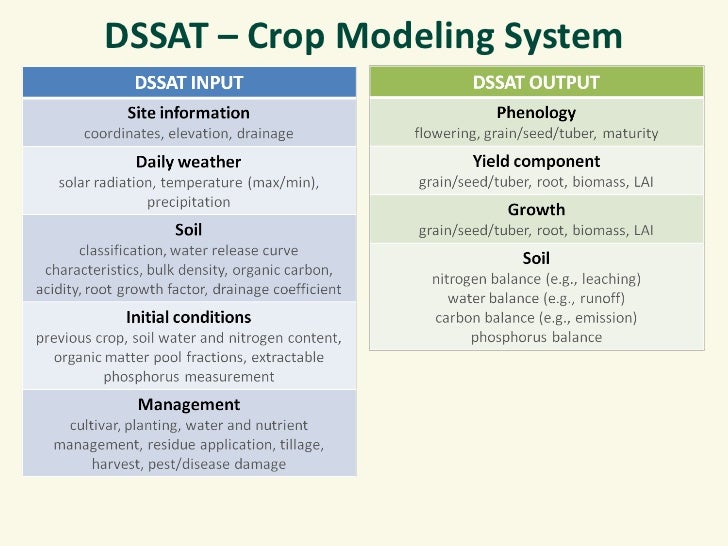
The DSSAT[25]
The DSSAT contains crop-soil simulation models, data bases for weather, soil, and crops, and strategy evaluation programs integrated with a user-friendly interface on microcomputers. In this paper, an overview of the DSSAT will be given, followed by example applications and a description of enhancements now being made. Concepts for using components of the DSSAT in new, broader decision support systems for assessing farm and regional outcomes of different policies and practices will be presented. These new tools will help decision makers by reducing the time and human resources required for analyzing complex alternative decisions.



2.In-season sensor-based algorithms for cereal grain production systems [31]
The demand for improved decision-making products for cereal production systems has placed added emphasis on using plant sensors in-season, and that incorporate real-time, site specific, growing environments.
The objectives of this work were to describe validated in-season sensor-based algorithms presently being used in cereal grain production systems for improving nitrogen use efficiency (NUE) and cereal grain yields. A review of research programs in the central Great Plains that have developed sensor-based N recommendations for cereal crops was performed. Algorithms included multiple land-grant university, government, and industry programs. A common thread in this review is the use of active sensors, particularly those using the normalized difference vegetation index (NDVI) for quantifying differences in fertilized and non-fertilized areas, within a specific cropping season. In-season prediction of yield potential over different sites and years is possible using NDVI, planting date, sensing date, cumulative growing degree days (GDD), and rainfall. Other in-season environment-specific inputs have also been used. Early passive sensors have advanced to by-plant N fertilization using active NDVI and by-plant statistical properties. Most recently, sensor-based algorithm research has focused on the development of generalized mathematical models for determining optimal crop N application. The development and promotion of fee-based modeling approaches for nutrient management continues. Nonetheless, several algorithms using active sensors for in-season N management are available from state and government sources at no cost and that have been extensively field tested and can be modified by producers.

3.Weed Control Decision Support System[32]
Weeds are a serious problem for agricultural crop. They rob main crops of sunlight, water and nutrient causing production losses both in quantity and quality. Losses due to weed were for wheat (9.8%), rice (10.8%), maize (13%), sorghum (17.8%), potatoes (4%) and groundnut (11.8%). Even, an uncontrolled weed can decrease yield until 20-80%. Herbicides are the dominant tool used for weed control in modern agriculture.
Although herbicide has positive benefit in killing the target weeds, it potentialy becomes negative impact if some remains in the air and drift. Spray drift from herbicide can cause crop protection chemicals to be deposited in undesirable areas. It has serious consequences such as damage to sensitive adjoining crops, damage to susceptible off-target areas, environmental contamination, illegal herbicide residues, lower yield results, and health risks to animals and people.The research was conducted by using remote sensing approach. It is useful to give a better understanding about the earth’s phenomenon. In this study, remote sensing used to study index of vegetation and weather condition. Crop phenology which identified through vegetation index used to know spray application time. Research conducted on paddy plantation.
The research was conducted by using remote sensing approach. It is useful to give a better understanding about the earth’s phenomenon. In this study, remote sensing used to study index of vegetation and weather condition. Crop phenology which identified through vegetation index used to know spray application time. Research conducted on paddy plantation. Remote sensing technology has capability to recognize the phases of plant growth through study of vegetation indices from planting to harvest. The growth phase of the study focused on the planting phase. Planting phase used to estimate the interval time of pre planting to post emergence. Then, that interval considered as the time for spraying. Weather variables during spraying time are studied in order to optimize the weed control and minimize negative impact to the environment.
Weed control method was developed by utilization of weather data that obtained from remote sensing. It became essential for area which sparse coverage of meteorology stations and requires a long time series data. Time series data in previous years used to optimize spray scheduling by looking for suitable weather condition and to prepare the spraying machinery and equipment for weed control that minimize the negative impact of herbicides to the environment.
In precision farming, weed control is done two times i.e. pre-planting and postemergence. To know these times, time for planting is identified first. Paddy planting time identified through multi-temporal analysis of vegetation index. Figure 4 showed pattern of enhanced vegetation index (EVI) of paddy field in study area which fluctuated during three years data observation. EVI clearly shows the annual vegetation growth cycle, representing intensive cropping with multiple harvests. The EVI pattern of paddy has an almost symmetrical bell shape. The vegetative growth stage correlated with the increasing EVI value until it reaches the maximum. The maximum of EVI value shows very green color from paddy leafs. It happens in heading/panicle stage.
Figure 5 shows weather pattern in Jonggol during ten years. This information is used to facilitate farmer or decision maker to know the weather condition before applying herbicide to protect the crop. By this information, problems on weed control such as drift and run-off can be minimized by preparing machinery and sprayer earlier before spraying time. Every parameter have own characteristic and generally in same fluctuated pattern form. Dry and wet season are clearly seen in weather pattern which affected by monsoon.
To find the ideal condition for spraying in ideal time and condition of each parameter based on reference and previous study is still hard to achieve. Therefore, software to determine nozzle sprayer size consider to weather condition will help overcome this limitation. The prototype interface of application to select the nozzle sprayer based on weather conditions while the knowledge is represented trough decision tree. Rainfall is the first parameter which decides do spray or do not spray, because spray application will not conducted in rainy day and herbicide particles will run off along with rain water. Wind becomes second parameter, following by temperature and humidity. Weather parameters can be inputted manually or can use weather data taken from the past data which stored in database.
References
[1] Rok Rupnik, Matjaž Kukar, Petar Vračar, Domen Košir, Darko Pevec, Zoran Bosnić (2019), AgroDSS: A decision support system for agriculture and farming, Computers and Electronics in Agriculture, Volume 161, Pages 260-271, ISSN 0168-1699.
[3] ncl.ac.uk
[4] research.ncl.ac.uk/nefg/ntoolbox/page.php?page=3
[7] solarimpulse.com/companies/weenat
[8] crunchbase.com/organization/vitalfields#section-overview
[9] en.smag.tech/our-software/crop-protection-yield-forecasts/precision-farming
[11] neuropublic.gr/projects/gaia-epichirein
[12] hidromod.com/main/hidromod
[13] organic-agriware.agroknow.gr
[14] agricon.de/agricloud
[16] cordis.europa.eu/project/rcn/97134/reporting/en
[17] evineyardapp.com
[19] cordis.europa.eu/project/rcn/194645/factsheet/en
[20] estacionavisos.agrointegra.intiasa.es/ai/accesoVisor.do
[22] mocccasin.eu/home
[23] clafis-project.eu
[24] wearaban.com/
[25] Jones, James (1993), Decision support systems for agricultural development. 10.1007/978-94-011-2842-128.
[26] slideshare.net/cgiarclimate/crop-modelling-with-the-dssat
[27] slideshare.net/ifpri/feeding-the-world-sustainable-agriculture-innovation-in-the-21st-century/21-DSSAT_Crop_Modeling_System
[28] L.M. Negm, M.A. Youssef, R.W. Skaggs, G.M. Chescheir, J. Jones (2014) DRAINMOD–DSSAT model for simulating hydrology, soil carbon and nitrogen dynamics, and crop growth for drained crop land, Agricultural Water Management, Volume 137, Pages 30-45, ISSN 0378-3774.
[29] researchgate.net/figure/Comparison-of-grain-yield-predicted-by-the-DSSAT-model-with-measured-values_fig10_325216541
[30] Xiaopei Tang, Ni Song, Zhifang Chen, Jinglei Wang & Jianqiang He (2018), Estimating the potential yield and ETc of winter wheat across Huang-Huai-Hai Plain in the future with the modified DSSAT model, Nature.
[31] Franzen, D., N. Kitchen, K. Holland, J. Schepers, and W. Raun (2016), Algorithms for In-Season Nutrient Management in Cereals, Agron. J. 108:1775-1781.
[32] Rizky Mulya Sampurno, Kudang Boro Seminar, Yuli Suharnoto (2013), Weed Control Decision Support System Based on Precision Agriculture Approach. Telkomnika.